


Soil Maps Online...
 11-06-2007, 06:36 PM
#1
Nontypical Buck
Thread Starter
Join Date: Feb 2007
Location: Denton, Texas
Posts: 1,335
Have to check it out:
Web Soil Survey (WSS) provides soil data and information produced by the National Cooperative Soil Survey. It is operated by the USDA Natural Resources Conservation Service (NRCS) and provides access to the largest natural resource information system in the world.
NRCS has soil maps and data available online for more than 95 percent of the nation’s counties and anticipates having 100 percent in the near future. The site is updated and maintained online as the single authoritative source of soil survey information.
http://websoilsurvey.nrcs.usda.gov
Here's an example:
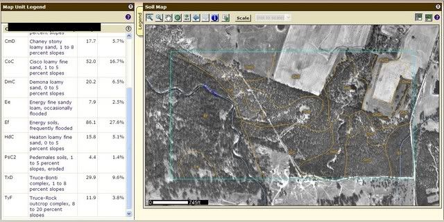
 11-07-2007, 08:37 PM
#2
Giant Nontypical
Join Date: Jan 2004
Location: a van down by the river
Posts: 8,939
It is a very handy reference tool. I've used it a bunch when making range improvement decisions, starting with my most productive land first, because it gives me a higher return for my dollar spent.
11-08-2007, 03:01 PM
#3
Nontypical Buck
Join Date: Dec 2006
Location: Lubbock, Texas
Posts: 1,401
I've have the hard copy of the soil maps for my county and I've used the online tool as well. It is pretty neat and is really nice to calculate acres by using the AOI highlighting tool for different areas on your land. I use it to calculate acres to know how much seed, fertilizer, etc. to buy.
I'm not so sure about how accurate the actual soil types are though. Many of these studies were done decades ago and based on working my land over the summer and fall I think some of it isn't correct on my property.
I'm not a geologist, but I sure don't thinkyou can draw a line in a field and say that the soil type on one side of the line is good and the soil on the other side of the line is bad. I have one field that shows up that way on the survey. I have another field that shows up as all one type of soil in the survey, but when I actually worked it this fall there is about 1/3rd of it that isclose to pea gravel,while the other 2/3rds of the field is nice soil.
I think the soil survey is a good place to start, and the AOI feature on the online tool to calculate area of odd shaped pieces of property is really good, but actually walking the land and putting a shovel or a tractor to work is better at actually determining where you have the best soil.
Here is an example of a very odd shaped field that I was able to map out and get the acreage on.
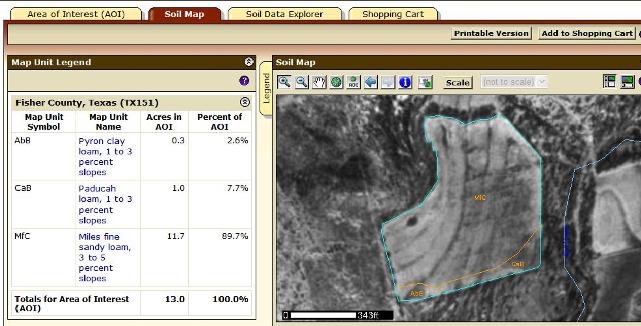
This is also the field that has some very different soil types when actually working it but on the soil survey it shows to be primarily all one type. (The rocky area runs pretty much north and south toward the middle of the field).
I'm not so sure about how accurate the actual soil types are though. Many of these studies were done decades ago and based on working my land over the summer and fall I think some of it isn't correct on my property.
I'm not a geologist, but I sure don't thinkyou can draw a line in a field and say that the soil type on one side of the line is good and the soil on the other side of the line is bad. I have one field that shows up that way on the survey. I have another field that shows up as all one type of soil in the survey, but when I actually worked it this fall there is about 1/3rd of it that isclose to pea gravel,while the other 2/3rds of the field is nice soil.
I think the soil survey is a good place to start, and the AOI feature on the online tool to calculate area of odd shaped pieces of property is really good, but actually walking the land and putting a shovel or a tractor to work is better at actually determining where you have the best soil.
Here is an example of a very odd shaped field that I was able to map out and get the acreage on.
This is also the field that has some very different soil types when actually working it but on the soil survey it shows to be primarily all one type. (The rocky area runs pretty much north and south toward the middle of the field).
11-18-2007, 09:57 PM
#4
Fork Horn
Join Date: Oct 2006
Location: Miami, Oklahoma
Posts: 422
ORIGINAL: npaden
I've have the hard copy of the soil maps for my county and I've used the online tool as well. It is pretty neat and is really nice to calculate acres by using the AOI highlighting tool for different areas on your land. I use it to calculate acres to know how much seed, fertilizer, etc. to buy.
I'm not so sure about how accurate the actual soil types are though. Many of these studies were done decades ago and based on working my land over the summer and fall I think some of it isn't correct on my property.
I'm not a geologist, but I sure don't thinkyou can draw a line in a field and say that the soil type on one side of the line is good and the soil on the other side of the line is bad. I have one field that shows up that way on the survey. I have another field that shows up as all one type of soil in the survey, but when I actually worked it this fall there is about 1/3rd of it that isclose to pea gravel,while the other 2/3rds of the field is nice soil.
I think the soil survey is a good place to start, and the AOI feature on the online tool to calculate area of odd shaped pieces of property is really good, but actually walking the land and putting a shovel or a tractor to work is better at actually determining where you have the best soil.
Here is an example of a very odd shaped field that I was able to map out and get the acreage on.
This is also the field that has some very different soil types when actually working it but on the soil survey it shows to be primarily all one type. (The rocky area runs pretty much north and south toward the middle of the field).

Thread
Thread Starter
Forum
Replies
Last Post
buckeye
Bowhunting
4
12-09-2005 07:35 PM
