


Where are you guys getting the aerials with topo overlay?

 09-17-2008, 09:59 PM
#12
Join Date: Dec 2005
Location: IL
Posts: 1,269
ORIGINAL: jmbuckhunter
Here is a scanned image of my place. when we were at the booth they pulled up a pic of Bols place, it had 1 red line on it. I have a few more that that.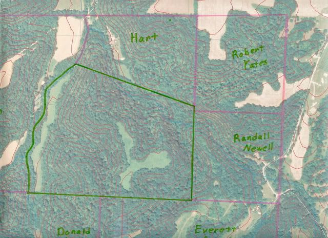
Here is a scanned image of my place. when we were at the booth they pulled up a pic of Bols place, it had 1 red line on it. I have a few more that that.
I was thinking.....I got some flat as a pancake land to hunt.
Definitely was a nice map for your place though. What size did they end up sending you, I couldn't remember?
09-18-2008, 05:45 AM
#14
Dominant Buck

Join Date: Oct 2005
Location:
Posts: 21,043
Grizzly has posted some overlays but I'm not sure if he made them his self.
If you've never spoken with Gri22.....do yourself a favor....and shoot him a PM. There isn't a nicer or more knowledgeable buck hunter I know of. Bar none (and with no disrespect to any others, here, or elsewhere).
He's helped me with topos tremendously.
I use the county GIS website and google earth for mine. hell Gri22 found mine FOR me.....(on google earth).

 09-18-2008, 08:16 AM
#17
Typical Buck
Join Date: Aug 2006
Location:
Posts: 725
I've been using this it doesn't have an overlay but you can switch back and forth from satelite to topo http://mapper.acme.com/
09-18-2008, 08:17 AM
#18
Typical Buck
Join Date: Aug 2008
Location: NOVA
Posts: 780
The county GIS is what I use. Some counties are easier and better then others, but almost all couties in the US have a GIS site. just google your county and GIS and it should comeup
09-18-2008, 08:19 AM
#19
Boone & Crockett
Join Date: Sep 2005
Location: Michigan/Ohio
Posts: 11,682

Thread
Thread Starter
Forum
Replies
Last Post
buckmaster
Bowhunting
11
11-05-2008 09:32 AM
