


First attempt to read a topo on new land
 09-05-2008, 09:50 AM
#1
Dominant Buck
Thread Starter

Join Date: Oct 2005
Location:
Posts: 21,043
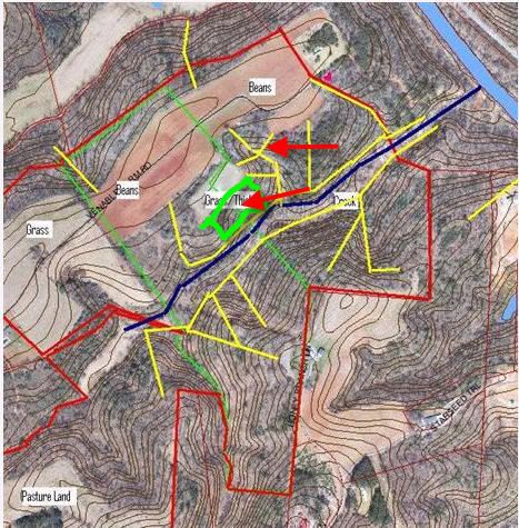
What do you think? I have marked the area I can hunt in red. Blue line is the creek. Fields are marked as to what's in them. The pink heart shaped spot is a stand I know another hunter has in there. Yellow lines are trails that I "think" will be good.
I know no one is hunting the land in red......legally. I've never hunted it, but I have full access to it, starting this year.
I have marked the places I "think" would be trails....based on 2 visits, there and my limited experience with reading topos. Most wooded areas have PLENTY of mast producing trees. Plenty.
Whatta ya think? I'm interested in hearing from some of you guys who do this a lot (read topos). I haven't spent much time up there......but it's only 45 minutes from my door to a tree, there.
Your thoughts?

 09-05-2008, 10:14 AM
#4
Fork Horn
Join Date: Sep 2007
Posts: 339
I'll bite. I don't know anything about topo's but the two places I've got marked with arrows look good. I like the security of the U shape made by the woodline. Also I think the deer will use the thicket for one of two things, staging or bedding. Either way both sides of the thicket should be productive.
 09-05-2008, 10:34 AM
#6
Dominant Buck
Thread Starter
Join Date: Oct 2005
Location:
Posts: 21,043
Brandon you're most likely right....and especially with the beans being in such close proximity, now. That upper red arrow area is REALLY thick. We couldn't walk through there....but the deer have little "cave-like" trails all through there.
The south side of the creek is AWESOME hardwoods....and though the creek doesn't show up on the aerial.....it's a roaring little creek. They have EVERYTHING they'd need in there even after the beans are gone.
Wouldn't you guys think the little, thin area where the terrain levels out a little.....south of the creek and east of my eastern-most yellow lines (within the red area)would be a good bench to hunt for the mast crops, there? What about the ridge on top.....just SE of there (where the red line intersects)?
 09-05-2008, 10:43 AM
#8
Nontypical Buck
Join Date: Sep 2004
Location: Manassas, VA
Posts: 3,612
I really got into topo map scouting this off-season. I suppose it will take me years of hard scouting/comparison to topo maps to be proficient. But I can tell you one thing....almost all of the big rubs I found out in the middle of the woods were made on the edges of saddles....and all the massive scrapes were placed directly in the middle of those saddles. I had never seen buck sign like this until I went out deep in the woods specifically looking for saddles based on the topo maps I looked over. I know have 4 saddles spaced out over a mile in the woods that I am REALLY looking forward to hunting come October 30th-November 20th....

09-05-2008, 10:47 AM
#9
Dominant Buck
Thread Starter
Join Date: Oct 2005
Location:
Posts: 21,043
Gri22...
It's thick as thieves in that spot, too. I need to get up there some evening next week to glass the areas. I can park at that old house (N on map and just below the grass designation)....and there's a tree or two in that hedgerow (S of your northernmost stand site and by the road) I can likely climb to spot from. I'll probably get pinned down, though.
I could see everything but the lower level fields to my right and S.....but I could probably see what came up from there as it got later.
Should be fun to go and see, anyways....and I need the practice with the new climber.
Gri22...
With that house in the lower portion and grass in the field above your other stand on that high place......why did you pick those two? I'm intrigued. When would you think they would be hot?
Also...I didn't denote a small power line right of way, earlier. I marked it with a white line on this map. If you look at a previous map....you can see it.
