


Map of hunting area...
 11-04-2007, 05:01 PM
#1
Nontypical Buck
Thread Starter
Join Date: Feb 2006
Location:
Posts: 1,796
OK, I would like advice if you have any on where you would set up on this land. Top of map is North.
Red X's are my stands. (Possibly moving 2 before rut)
White O's are Hunting Club members' stands just across our property lines.
Dark Blue lines are medium to large creeks.
Light Blue line is a small draw in a bottom with fair amount of cover running the length of it.
Green line is a Pipeline road (unused except by me)
White Outlined square is Mature Hardwoods/Pines (feeding area)
Yellow Outline square is Thicket (all except some mature hardwood running along the creek)
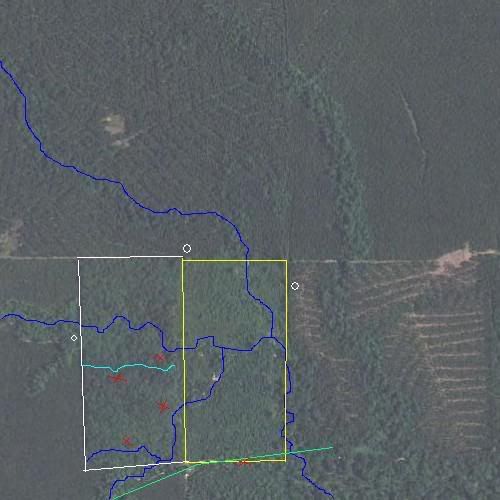
By the way, the 2 squares together are 40 acres total.
Thanks, LT
Red X's are my stands. (Possibly moving 2 before rut)
White O's are Hunting Club members' stands just across our property lines.
Dark Blue lines are medium to large creeks.
Light Blue line is a small draw in a bottom with fair amount of cover running the length of it.
Green line is a Pipeline road (unused except by me)
White Outlined square is Mature Hardwoods/Pines (feeding area)
Yellow Outline square is Thicket (all except some mature hardwood running along the creek)
By the way, the 2 squares together are 40 acres total.
Thanks, LT


Thread
Thread Starter
Forum
Replies
Last Post
W_IL_BowHunter
Midwest
2
11-10-2004 12:08 PM
