


How I read a Topo/Sat. Map
 01-18-2007, 09:11 AM
#1
Boone & Crockett
Thread Starter
Join Date: Sep 2005
Location: Michigan/Ohio
Posts: 11,682
The questions was ask how do you read these maps. Here is what I look for, maybe Gregh,Greg/Mo, Buckeye, Roband others can throw in there .02 cents.
What I look for are changes in the terrain, choke points, inside edges(in the woods), inside corners, escape routes, North and South Trails.

North is straight up
The above is north side of the property I hunt. We can see some fence lines and some really good choke points right off the bat.
Also in the wood lot you can see a "break" in the trees. I have it mark in red below. This is what I call an "inside Edge" and is a great place to start to look when you scout on foot.
What I look for in a Bedding area is
1.Cover
2.Accesibilty
3.Access to food and water
4.Escape routes.
4 is the key for mature bucks(IMO), a mature buck is NOT going to back himself into a corner.
The bedding area here has all 4, but the issue with both these area's are so thick you can not hunt them. So I look for trail a buck might use. This is where I look for a seldom used North to South trail. Why? The wind is from the W-SW most of the time. During the Rut a buck will scent check a bedding area and he will scent check it before he goes in the early season. A lot of times he will run a trail to check, if the wind is coming out of the west, he might use this trail to crusie through and check. On this spot we have a great "trail" that does this. Marked in red(same as break we can see), the entry trails to this bedding are are marked in Yellow. Now Even though for this location there is not a "main" trail in or out. I can hunt the bedding area by hunting this 1 trail.
Thishelps withnot spreading my scent around by have 2 or three setups in this small area.
recap I look for
1.Choke points
2.Break inthe woods(inside Edges)
3.Access to food and water from a bedding area
4.Escape routes for a buck.
Below is the map I have marked up. Blue is the stand location. Yellow are the entry trails for the bedding area.
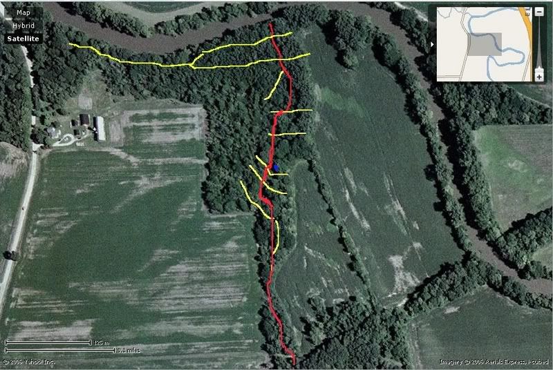
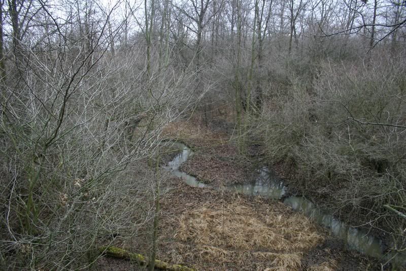
Here is the stand, you can see the gully, which is the break in the woods you can see on the map, marked in red. Now look at the top map and you can see the break. I hunt here because this is where the funnel comes in. The bank in the east side isclose to the back on the west side.The trailthen runs dead north past this point. Which is the THICKEST part of the bedding area, and right in the middle.
That is whatI do, sometimes it works, and sometimes it does not!
What I look for are changes in the terrain, choke points, inside edges(in the woods), inside corners, escape routes, North and South Trails.
North is straight up
The above is north side of the property I hunt. We can see some fence lines and some really good choke points right off the bat.
Also in the wood lot you can see a "break" in the trees. I have it mark in red below. This is what I call an "inside Edge" and is a great place to start to look when you scout on foot.
What I look for in a Bedding area is
1.Cover
2.Accesibilty
3.Access to food and water
4.Escape routes.
4 is the key for mature bucks(IMO), a mature buck is NOT going to back himself into a corner.
The bedding area here has all 4, but the issue with both these area's are so thick you can not hunt them. So I look for trail a buck might use. This is where I look for a seldom used North to South trail. Why? The wind is from the W-SW most of the time. During the Rut a buck will scent check a bedding area and he will scent check it before he goes in the early season. A lot of times he will run a trail to check, if the wind is coming out of the west, he might use this trail to crusie through and check. On this spot we have a great "trail" that does this. Marked in red(same as break we can see), the entry trails to this bedding are are marked in Yellow. Now Even though for this location there is not a "main" trail in or out. I can hunt the bedding area by hunting this 1 trail.
Thishelps withnot spreading my scent around by have 2 or three setups in this small area.
recap I look for
1.Choke points
2.Break inthe woods(inside Edges)
3.Access to food and water from a bedding area
4.Escape routes for a buck.
Below is the map I have marked up. Blue is the stand location. Yellow are the entry trails for the bedding area.
Here is the stand, you can see the gully, which is the break in the woods you can see on the map, marked in red. Now look at the top map and you can see the break. I hunt here because this is where the funnel comes in. The bank in the east side isclose to the back on the west side.The trailthen runs dead north past this point. Which is the THICKEST part of the bedding area, and right in the middle.
That is whatI do, sometimes it works, and sometimes it does not!
 01-18-2007, 09:20 AM
#2
Nontypical Buck
Join Date: May 2006
Location: Southwest Ohio
Posts: 2,849
Just curious, have you tried hanging a stand south of your current position just inside where that corner comes in from the west? That is a place that I would normally look and wondering what, if anything, is there.
The major things I look for on a topo, to add to your suggestions,are saddles on ridgetops (not applicable to you flatlander ) as well as large flats on the tops of ridges. These are major funnels and areas for rutting bucks in my experience.
The major things I look for on a topo, to add to your suggestions,are saddles on ridgetops (not applicable to you flatlander
) as well as large flats on the tops of ridges. These are major funnels and areas for rutting bucks in my experience.
01-18-2007, 09:33 AM
#3
Boone & Crockett
Thread Starter
Join Date: Sep 2005
Location: Michigan/Ohio
Posts: 11,682
ORIGINAL: huntingson
Just curious, have you tried hanging a stand south of your current position just inside where that corner comes in from the west? That is a place that I would normally look and wondering what, if anything, is there.
The major things I look for on a topo, to add to your suggestions,are saddles on ridgetops (not applicable to you flatlander) as well as large flats on the tops of ridges. These are major funnels and areas for rutting bucks in my experience.
Just curious, have you tried hanging a stand south of your current position just inside where that corner comes in from the west? That is a place that I would normally look and wondering what, if anything, is there.
The major things I look for on a topo, to add to your suggestions,are saddles on ridgetops (not applicable to you flatlander
) as well as large flats on the tops of ridges. These are major funnels and areas for rutting bucks in my experience.
Yes there sure is a funnel thereand Iwould love to hunt there, but not a damn tree[:@]
Yes the bedding here is on top of the gully, like a mini ridge. Good point
 01-18-2007, 10:38 AM
#4
Nontypical Buck
Join Date: Aug 2005
Location: Almost Heaven. Boone Co. WV
Posts: 1,002
Neat set-up Germ.Looks like somenasty brush where your stand is.
Like huntingson I look for low gaps along ridgelineswhere the trails intersect. If I can find a spot on the edge of the saddle where bucks will skirt through the area, I will set up there. The wind in WV where I hunt has a tendency to swirl a lot especially on a ridgeline, so getting too close is risky.
Most of the tme I am forced to back up my stand position to a possible staging area that presents a favorable more predictable wind.
I then tryto locate the best position along an inside edge.
Neat stuff!
 01-18-2007, 03:00 PM
#9
Boone & Crockett
Thread Starter
Join Date: Sep 2005
Location: Michigan/Ohio
Posts: 11,682
ORIGINAL: RWK
What site did you get the topo from. Thanks Rich
What site did you get the topo from. Thanks Rich
I got the Satellite's from yahoo maps
http://maps.yahoo.com/;_ylc=X3oDMTExNmIycG51BF9TAzI3MTYxNDkEc2VjA2ZwLWJ1 dHRvbgRzbGsDbGluaw--#env=F
01-18-2007, 03:36 PM
#10
Giant Nontypical
Join Date: Feb 2003
Location: PA
Posts: 9,085
excellent post Germ!
my first stand selection off the bat was where huntingson would been hunting!! thats an awesome looking funnel..your spot looks great too. i bet its kind of a staging area/access point to either field. i love that somewhat secluded field corner your near.
when scouting new areas topos and sattalite pics are my favorite tool. can really save on leg work. dad taught me to read a topo before i could pee straight. now with todays age of sattalite and ariel pics on the internet IMO them coupled with good topos are priceless. if your good you can almost pick your stand locations before stepping foot in the woods. but like me and huntingson...there just might not be a tree around so you still gotta get out there.
looking forward to your topo session!! great post...thanx for sharing.