


An aerial photo of a place of interest....
 01-15-2007, 11:07 PM
#1
Giant Nontypical
Thread Starter
Join Date: Aug 2003
Location: The OH-IO
Posts: 7,103
This is a farm that I hunted twice. Once last year once the year before. I want to hunt this place a little more this year however. It is tuff to get to except on weekends or vacation as it is over a 2 hour drive.
I can tell you the fields are rotated every year with corn, beans, and alfalfa. The timber to the north and norteast within the black circle is fairly open and consists of very large sycamore trees for the most part, with some small scrub trees mixed in. The timber to the west downwhere the two rivers peak is a mixed softwoods stand for the most part. It is much thicker and serves as the main bedding area.
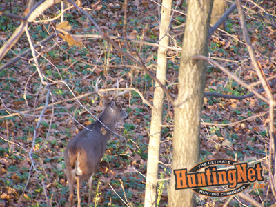
I have never scouted this place except for walking the filed edges once and hunted it twice blind. I did see deer both times however with one being a pretty decent buck. I will add a photo of him as well. I saw him in the red dot farest to the west.
My main point of interest for the rut next year is where the small island to the west meets up with the main ground I can hunt.
Red is where I hunted.
Blue is a deep river to the North and a decently deep creek to the south.
Black is the property boundry.
Yellow dot is parking.
Here is the map...

Here is the buck I spoke of.
I can tell you the fields are rotated every year with corn, beans, and alfalfa. The timber to the north and norteast within the black circle is fairly open and consists of very large sycamore trees for the most part, with some small scrub trees mixed in. The timber to the west downwhere the two rivers peak is a mixed softwoods stand for the most part. It is much thicker and serves as the main bedding area.
I have never scouted this place except for walking the filed edges once and hunted it twice blind. I did see deer both times however with one being a pretty decent buck. I will add a photo of him as well. I saw him in the red dot farest to the west.
My main point of interest for the rut next year is where the small island to the west meets up with the main ground I can hunt.
Red is where I hunted.
Blue is a deep river to the North and a decently deep creek to the south.
Black is the property boundry.
Yellow dot is parking.
Here is the map...
Here is the buck I spoke of.
 01-15-2007, 11:47 PM
#2
Giant Nontypical
Join Date: Feb 2003
Location: Jackson, Missouri
Posts: 7,051
Any thoughts of hanging up in one of the ends of that strip connecting the hourglass shape of the area? Depending upon prevailing winds, you could hunt either the north tip or the bottom south tip... and be farther away from the parking area, too... if other hunters access the farm via that way.
01-15-2007, 11:58 PM
#3
Giant Nontypical
Thread Starter
Join Date: Aug 2003
Location: The OH-IO
Posts: 7,103
Greg, that is definitely a point of interest especially if there is corn in the back fields. As you mentioned getting away from others, that's why I want to go all the way back to that island. I bet I see no one at all back there.... Perfect place to hang all day. If there is any pressure from the front it should help me out...
It is a mile (in a straight line) from the parking area to the back side of the field with the "hour glass center". Following the tractor trail it is over two miles to get back to that island.
[/align]
01-16-2007, 12:04 AM
#4
Join Date: Dec 2005
Location: IL
Posts: 1,269
I was also going to say that would be a perfect spot of interest.
If there is any trail at all in either the north or south point of the hourglass, you would have to call that stand "Grim Reaper's Perch".
If there is any trail at all in either the north or south point of the hourglass, you would have to call that stand "Grim Reaper's Perch".
01-16-2007, 02:17 AM
#5
Giant Nontypical
Join Date: Feb 2004
Location: Pittsburgh, PA
Posts: 7,208
Yea 1st thing that popped into my head was that finger justting downand near the river on each side of it. I'm sure there is also some good areas that don't show up on the map in that big chunk of woods to the west.
01-16-2007, 07:13 AM
#7
Boone & Crockett
Join Date: Sep 2005
Location: Michigan/Ohio
Posts: 11,682
ORIGINAL: buckeyebuckhntr
Greg, that is definitely a point of interest especially if there is corn in the back fields. As you mentioned getting away from others, that's why I want to go all the way back to that island. I bet I see no one at all back there.... Perfect place to hang all day. If there is any pressure from the front it should help me out...
It is a mile (in a straight line) from the parking area to the back side of the field with the "hour glass center". Following the tractor trail it is over two miles to get back to that island.
[/align]
I like the back also, do you have a boat? Works great, get an eletric trolling motor and you run silent.
1. you do not get a hot from walking
2. silent and you will spook far less deer.
3. I walk on average 10 steps to those stands. So your sent trail will me light, almost not there.
On the south side have you fond where the cross the river, I would setup there. I would bet you could catch one sneaking a cross here one morning.
The yellow would be morning Rut stands only andI would only hunt them in my boat. When the wind is right for those stands.
Red would be evening and boat only also. I can tell you this, I would not walk anywhere on here. It is setup perfect for river entry.
John Boat 10 ft is whatI have. Let me know I will bring down and we can do a test run ifyou like.
 01-16-2007, 08:48 AM
#8
Fork Horn
Join Date: Aug 2004
Posts: 169
Bowtech-1, If you want a really great way to map out your hunting area from aerial photos go to www.jdmcox.com and download the program there. I did it just the other day and now have maps with every hunting spot marked, trails, scrpaes etc. for any place I hunt. It's the neates program I've seen for this stuff.
01-16-2007, 09:09 AM
#9
Giant Nontypical
Thread Starter
Join Date: Aug 2003
Location: The OH-IO
Posts: 7,103
One problem with that hour glass shape in the center is there is about 100 yards of open field between the points of them. This is why I think it would be a better setup with corn bordering the center funnel. Also, it is basically a "hedgerow" along the creek to the south leading to the funnel from the west.
I know bucks use it as there were some nice scrapes over there.
What else this map doesn't really show you is everything to the NE and Sof the area circled in black has very large hills, I am talking some BIG hills.... Although this river bottom is flat as a pancake....
Germ,
I do not own a john boat but have access to one. My problem would be getting the boat to and from the water with me as I could not leave it there.
01-16-2007, 09:18 AM
#10
Boone & Crockett
Join Date: Sep 2005
Location: Michigan/Ohio
Posts: 11,682
ORIGINAL: buckeyebuckhntr
One problem with that hour glass shape in the center is there is about 100 yards of open field between the points of them. This is why I think it would be a better setup with corn bordering the center funnel. Also, it is basically a "hedgerow" along the creek to the south leading to the funnel from the west.
I know bucks use it as there were some nice scrapes over there.
What else this map doesn't really show you is everything to the NE and Sof the area circled in black has very large hills, I am talking some BIG hills.... Although this river bottom is flat as a pancake....
Germ,
I do not own a john boat but have access to one. My problem would be getting the boat to and from the water with me as I could not leave it there.
If you want I can come down and we can take a ride. Just so you can see how it looks. For some reason I get a different perspective from the river and how the deer move.