


Scouting Maps
 08-22-2006, 12:27 PM
#1
Typical Buck
Thread Starter
Join Date: Feb 2003
Location: North Dakota
Posts: 959
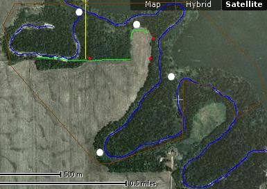
The brown area indicates the property limits. The river that makes a hook is probably dried up this year since it has been so dry. I was wondering if it would be a good idea to put a stand up along the dried river beed on the south side, closest to the green line. The green line indicates where I have seen signs of a buck EVERY year since I have been hunting. The yellow line indicates a powerline. It seems like ever year there has been a big buck or two within the dried up part of the river bed.the red dots are possible stand locations. I was also wondering if I shouldn't put one at the end of the green trail on the south side of the deer trail. Or if I should just put one where the trail and powerline intersect.

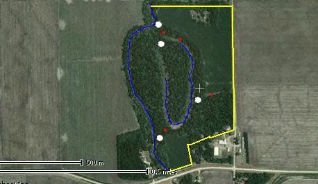
Here is another section of property that I am going to try and get permission to hunt. Yellow indicates the property line, and it would be east of the river that I could hunt. This is also another area that will probably have a dried up river bed in the are that creats kind of a hook. This section as produced some nice bucks too. It seems like in the past they have come out and fed in the field on the north side of the woods by where I have the two possible stand locations. (don't know why I have put them so close together) I guess it is an either or type of deal. I was just wondering if it would be best to put them on the edge of the dried up river so if there are bucks waiting just inside the woods while the does go out and start to feed. The red dot on the south side of the woods by the small field is where I have seen quite a few deer feeding every year that we go out for shotgun season. The red dot just north of the house is a possible stand location just in case there is a wind from the west and the deer are also feeding down in that corner of the field

Sorry for the long post, but I was just looking for some input. I will probably have some more maps of two more areas that I am going to try to get stands in before the rut hits full swing. One is just an extension on the other side of the road from the first section. And the other one is about a mile north of the second map.
Here is another section of property that I am going to try and get permission to hunt. Yellow indicates the property line, and it would be east of the river that I could hunt. This is also another area that will probably have a dried up river bed in the are that creats kind of a hook. This section as produced some nice bucks too. It seems like in the past they have come out and fed in the field on the north side of the woods by where I have the two possible stand locations. (don't know why I have put them so close together) I guess it is an either or type of deal. I was just wondering if it would be best to put them on the edge of the dried up river so if there are bucks waiting just inside the woods while the does go out and start to feed. The red dot on the south side of the woods by the small field is where I have seen quite a few deer feeding every year that we go out for shotgun season. The red dot just north of the house is a possible stand location just in case there is a wind from the west and the deer are also feeding down in that corner of the field
Sorry for the long post, but I was just looking for some input. I will probably have some more maps of two more areas that I am going to try to get stands in before the rut hits full swing. One is just an extension on the other side of the road from the first section. And the other one is about a mile north of the second map.
 08-23-2006, 10:15 AM
#3
Fork Horn
Join Date: Feb 2003
Location: NEW ATHENS, IL, USA
Posts: 426
Any info on common wind direction? It looks like there may be some key funnels you could be overlooking.
On the bottom map I'd look at possibly moving one site to the North right at the bend of the river where that little finger of woods runs along the river.
On the bottom map I'd look at possibly moving one site to the North right at the bend of the river where that little finger of woods runs along the river.
08-23-2006, 02:53 PM
#4
Typical Buck
Thread Starter
Join Date: Feb 2003
Location: North Dakota
Posts: 959
not 100% where the wind usually blows from, mostly north south it seems like when we are hunting during shotgun. didn't get out with the bow last year very much and still have to get out and place a trail cam or two to see what is in the area..or sit out there for a couple days one weekend if I can't cough up the money for a cam.
Would you be willing to show me where you would possibly put some stands?
Would you be willing to show me where you would possibly put some stands?
08-23-2006, 04:02 PM
#5
Giant Nontypical
Join Date: Dec 2004
Location: Ohio
Posts: 7,876
Very nice maps Buck! I can't see any realAriel help, looks like pretty flat ground. I'd think that power line run would be a night time active spot but I have seen other wise and often. What I mean is don't count on it being used during legal light. The way I hunt is I pick the spot I think best and see what happens. Typically I'm close but need to move some.I like inside corners.
Top pic, upper left corner, end of green line, smallinside corner of green area. I'd put one there. Easy to get to and then I'd move from there if needed.
Very nice job Buck!
Top pic, upper left corner, end of green line, smallinside corner of green area. I'd put one there. Easy to get to and then I'd move from there if needed.
Very nice job Buck!
 08-24-2006, 12:02 PM
#7
Typical Buck
Thread Starter
Join Date: Feb 2003
Location: North Dakota
Posts: 959
Thanks a bunch, the second pic where you said you would put your stand across the creek is the very first spot I ever put a stand. No luck though, but then again it was my first year out and didn't really know much about hunting. And I have shot a deer in the most southern spot you said to put a stand, would be an alright spot because there is a lot of open area. Also have sat in the 'bay area' where the green trail kind of ends. Thanks alot for all the help guys. I will definately try out some of those spots you showed me, Dumb Bass
08-25-2006, 05:28 AM
#8
Typical Buck
Thread Starter
Join Date: Feb 2003
Location: North Dakota
Posts: 959
I am going to try to get out to both farms next weekend and break out the old binocs to see where they are coming out to feed...I will try to snap some pictures with them if there are any nice bucks. I haven't got to try that feature out yet, my sister gave them to me for christmas and they went MIA for a couple years and now I found them when we were cleaning out my closet.

